|
Castine, Maine and Acadia National Park 
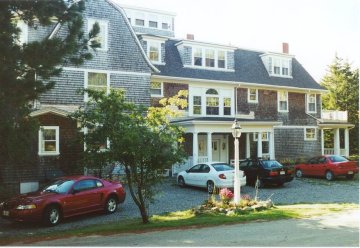 During the peak of the foliage season in Castine, Maine during the long Columbus Day Weekend we rented the Northrop Grand Cottage (more like a Mansion!) located right on a Maine peninsula with sweeping ocean views.
It is also conveniently located near Acadia National Park with its carriage trails and hiking paths offering easy access to the beauties of mountains, lakes and sea, all in one place. In the evenings, we took trips to nearby Bar Harbor and enjoyed steamed lobster (and other local fare) at several of the famous New England eateries. 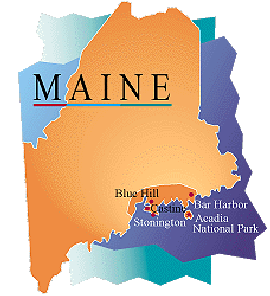
The Northrop Cottage offers the gracious living of a bygone era, graced with period details and antiques. With three full floors (and a fourth floor loft just right for Dan) and over 7,000 square feet of living space, Northrop Cottage sleeps 19. 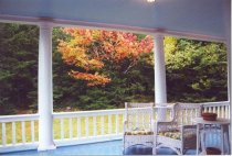 Amenities: 5 fireplaces, 4 porches, 3 staircases (that contain more square footage than my entire house), full kitchen with gas grill, dishwasher, microwave, super capacity washer/dryer, satellite TV/VCR, CD player, telephone, and utensils and linens and towels provided. The photograph on the right is from Nick, and shows the side porch of the house.
A spring-fed well, visited by Native Americans for its water's medicinal properties, is near and an apple orchard can also be spotted in front of the carriage house. It's a great chance to meet new friends and old at a place with incredible scenic beauty, in the comfort of an historic New England home. Castine is approximately 5 hours north of Boston. (It may be as short as 4 - 4.5 if there's no traffic!) The best route is to take 95 North to Maine and then follow the directions as provided below: Directions from Boston: Take 95N through NH and into Maine. Take 295N through Portland, ME (45 min N of Portsmouth, NH). 295N turns back into 95N north of Portland. Take 95N to August and then exit for Route 3 (signs mention the Downeast/Acadia region). Follow Route 3 through Augusta - there are several turns but all are well-marked. Follow Route 3 to Belfast (45 min) and then join Route 1N to Bucksport. (20 more minutes to Bucksport.) Cross large suspension bridge -- see Bucksport across river. Cross second low bridge into Bucksport and bear right - (Mobil station on right followed by Shop 'n Save Supermarket on right -- best place to grocery shop before going to Castine.) Continue through Bucksport for about 1 1/2 miles (this means taking a right out of the Shop 'n Save parking lot). See sign for Castine on right and turn right on Route 175 - Castine (15 more min to Castine). From this point, you may follow the (yellow marked) directions on the local map. According to the local map Route 175 eventually becomes Route 166A, then converges with Route 166 into Castine, and Route 166 then becomes State Street inside the town. Turn right at Battle Avenue. The house is on the right, and nearly at the end of the street. It looks to be within view of a lighthouse at the edge of Penobscut River. There isn't a house number and the house can't be seen from the road. The best landmark is to watch for The Manor Inn on the right hand side of Battle Avenue when heading into town. The driveway is on the right about 1/2 mile past The Manor. Watch for two large stone pillars with boulders on top. There is a phone at Northrop Cottage for local calls and calling card calls. The phone number there is: 207.326.4596. You may want to share this number with the other guests so that you are all accessible in the case of an emergency. Please let me know what time the first guests will be arriving on October 5th (also the name of a contact person in the group is helpful). My sister, Faith, will meet you at the house to provide you with a tour and show you where things are and how everything works. VACATIONERS PROVIDENCE, RHODE ISLAND Mary: Flying into Providence, RI at 10:25 am Thursday, and renting a car for the drive north to Castine. Janice: Flying into Providence, RI at 10:25 am Thursday, and riding with Mary S for the drive north to Castine. BOSTON, MASSACHUSETTS Bill: Flying American Airlines into Boston Wednesday afternoon, staying overnight in Watertown, MA, then renting a car for 8 am drive north to Bangor, then to Castine. Ward: Flying into Boston, MA at 10:20 am Thursday, then renting a car for drive north to Castine. Nicole: Flying into Boston, MA at 10:20 am Thursday, riding with Ward S. Michael: Flying into Boston, MA, riding with Ward. BANGOR, MAINE Harriet: Flying into Bangor, ME at 3:10 pm Thursday, then riding with Bill Atkins. Maureen Flying into Bangor, ME at 3:10 pm Thursday, then riding with Bill Atkins. PORTLAND, MAINE Dan: Flying USAir 4631 into Portland, ME 11:35 am, renting a car for drive north to Castine. Nancy: Flying USAir 3648 into Portland, ME at 10:30 am Thursday, riding with Dan. Thomas: Flying into Portland, ME at 10:30 am Thursday, riding with Dan. Laurie: Flying USAir into Portland, ME at 11:35 am Thursday, and riding with Dan for drive north to Castine. Nick: Flying USAir 2056 into Portland, ME at 10:58 am Thursday, renting a car for drive north to Castine. DRIVING Tom: Driving in on Friday Laura: Driving in on Friday  The Northrop cottage greets us as we wind our way up the road leading from Battle Avenue up to the house. After exploring the four floors of the house and finding our bedrooms for the weekend we all gathered into several cars to buy groceries at Tarratine Market on the corner of Main Street and Water Street. Then it was off to dinner at Dennett's Wharf (15 Sea Street), on the water's edge at the end of Green Street. The restaurant has a great view of the harbor from the newly renovated deck, which sports an all-weather tent-style enclosure that can be rolled back in good weather. It is reported in Welcome to Castine on the web that the "owner contributes a lot of time and money to the town's worthwhile causes, so you can feel good about knocking back a few more Maine microbrews here". The Northrop cottage greets us as we wind our way up the road leading from Battle Avenue up to the house. After exploring the four floors of the house and finding our bedrooms for the weekend we all gathered into several cars to buy groceries at Tarratine Market on the corner of Main Street and Water Street. Then it was off to dinner at Dennett's Wharf (15 Sea Street), on the water's edge at the end of Green Street. The restaurant has a great view of the harbor from the newly renovated deck, which sports an all-weather tent-style enclosure that can be rolled back in good weather. It is reported in Welcome to Castine on the web that the "owner contributes a lot of time and money to the town's worthwhile causes, so you can feel good about knocking back a few more Maine microbrews here".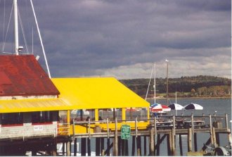 The outside view of Dennett's Wharf is provided by Nick. The outside view of Dennett's Wharf is provided by Nick.
History Lesson #1 (Quiz at the end of page 2): The discovery of the area now called Castine began when Samuel de Champlain, geographer to King Henry IV stepped ashore in 1604 on ground now known as the Castine peninsula. Eager to begin trade within the region a French trading post was established around 1613-1614. Its location is described as being on the eastern side of what today is called Penobscot Bay. This mouth of two rivers was called by the French the peninsula Pentagoet. In 1614 Captain John Smith charted this coastal area for British interests. Governor William Bradford of Massachusetts received a grant to the Castine area in 1626 with an objective to repay his debts from establishing the Plymouth Colony. Eventually, Isaac Allerton established a trading post, naming the area Majabagaduce. Conflicts were common between the French and English colonists.During the time of settlement Jean Vincent d'Abbadie de St. Castin was born to a distinguished French family in Oleron, France in the foothills of the Pyrenees. At the age of 13 or 14 Castin was sent to Quebec (in 1665) to join the Carignan Salieres regiment. At the end of the war between France and England, Castin was granted from the King the land in the vicinity of Pentagoet. During this time Castin found a fort at Pentagoet and settled at a site further up the Bagaduce River. He eventually married the Mathilde, the daughter of his mentor and confidant Madockawando, a sagamore of the Tarratines. In 1701 Castin returned to France to claim his family estate and title. 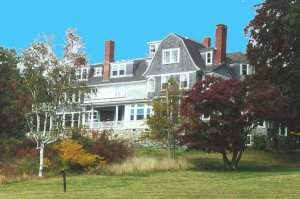 After a wonderful meal, a chance to get to know new friends, and the site of gobs of money plastered on the ceiling of the restaurant, we retired for the night. In the morning we found a day full of fog and rain. Not a good start of vacation, but (nevertheless) we weren't deterred as some of us left for breakfast at a local restaurant (with Dan - as usual - in the lead) and others to begin the exploration of Acadia National Park. After a wonderful meal, a chance to get to know new friends, and the site of gobs of money plastered on the ceiling of the restaurant, we retired for the night. In the morning we found a day full of fog and rain. Not a good start of vacation, but (nevertheless) we weren't deterred as some of us left for breakfast at a local restaurant (with Dan - as usual - in the lead) and others to begin the exploration of Acadia National Park.
History Lesson #2 (It's an essay test, plus several multiply choice questions): The British flag was flown above the abandoned French fort in 1759 when Governor Pownal of Fort Point (Stockton) resettled the area with farmers who cleared the land and fuilt their farmhouses north and west of the Fort Pentagoet site. Realizing the military importance of the area for a convenient source of timber for masts and other supplies, General Francis McLean in June 1779 landed at the foot of what is now Main Street with 700 soldiers. They established Fort George, the highest point on the peninsula. Today the ruins of Fort George is contained within Fort George State Park. The first hanging in Hancock County took place here. And the ghost of a drummer boy is said to be heard drumming in August (a possible scary story for Maureen and Harriet to tell). Word of the British occupation of the area reached the Massachusetts Board of War resulting in eighteen armed vessels and 24 transports, carrying 1,000 ill-trained militia men and 400 marines to be dispatched to recapture the fort. Colonel Paul Revere was the ordnance officer under the land command of Brig. General Solomon Lovel while Commodore Dudley Saltonstall comanded the naval force. Considered by some historians as the worst American naval defeat in history, the American leaders couldn't agree on a plan of attack, and were eventually fought off by 18-year-old Lieutenant John Moore, hero of the Napoleonic wars. In 1787 the present towns of Castine, Penobscot, and a part of Brooksville were incorporated into one town called Penobscot. The town of Castine split off from Penobscot in 1796 and grew rapidly as shipyards spring up and merchants prospered as Castine became a port of entry and a customs house was established. 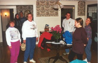 Janice, Mary, Harriet and Dan (in the background), Nick, Nancy, and Laurie ready themselves for their first day of vacation, with plenty of rain gear, mittens, and cameras. Janice, Mary, Harriet and Dan (in the background), Nick, Nancy, and Laurie ready themselves for their first day of vacation, with plenty of rain gear, mittens, and cameras.Acadia National Park is located on the rock-bound Maine island of Mount Desert. The park, established in 1916, is a 40,000 acre wilderness area contained within two-fifths of Mount Desert Island (pronounced like dessert after being named by Champlain, the great French explorer). Acadia is the only national park in New England. The island is the third largest islands on America's East Coast (behind Long Island in New York Martha's Vineyard off the coast of Cape Cod in Massachusetts) with 108 square miles. Inside the park we found soaring granite cliffs side by side with sand and cobblestone beaches. Glacier-carved mountains rear up from the sea, cupping deep lakes in their valleys. But, there is even more. Meadowlands and marshes, and dense evergreen forests make their appearance known, and everywhere the ocean makes its presence felt. 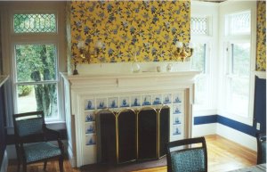 One of four fireplaces scattered throughout the house is shown in the dining room, that is situated in the corner between the sun room and the kitchen. Several nights of competitive Trivial Pursuit was played at the dining room table. One of four fireplaces scattered throughout the house is shown in the dining room, that is situated in the corner between the sun room and the kitchen. Several nights of competitive Trivial Pursuit was played at the dining room table.Castine was established as a trading post by the Plymouth Pilgrims (they subscribed to the sail now, pay later ethic; they were obliged to earn money to pay for the Mayflower) and is the only community in the county to have flown under four national flags--U.S., England, France, and Holland. There is a very active local historical society, which has placed markers all over town celebrating various noteworthy occurrences  Laurie is seen in the living room where a second fireplace is located. However, none of the fireplaces worked. Should we call them "nofireplaces"? The living room is off the parlor, at the front entrance to the house. Laurie is seen in the living room where a second fireplace is located. However, none of the fireplaces worked. Should we call them "nofireplaces"? The living room is off the parlor, at the front entrance to the house.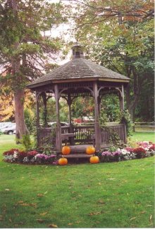 Nick photographed this gazebo that stands outside of the Bar Harbor Inn within the town of Bar Harbor, Maine. We ate lunch at Joe's Smoke House in Bar Harbor before going off to explore Acadia National Park. The gourmet group ate inside the restuarant, while the take-out group ate in the car on the way to the park. The restaurant serves a great lobster roll! Nick photographed this gazebo that stands outside of the Bar Harbor Inn within the town of Bar Harbor, Maine. We ate lunch at Joe's Smoke House in Bar Harbor before going off to explore Acadia National Park. The gourmet group ate inside the restuarant, while the take-out group ate in the car on the way to the park. The restaurant serves a great lobster roll!
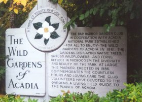
Acadia National Park: (1) is the first national park east of the Mississippi River, (2) is the first national park whose land was donated entirely by private citizens, (3) encompasses more than 40,000 acres, (4) contains about 165 species of common native plants, about 60 species of land and marine mammals, and more than 150 breeding species of birds call the park home, and (5) contains 45 miles of picturesque carriage roads, more than 120 miles of hiking trails, and more than 500 campsites. 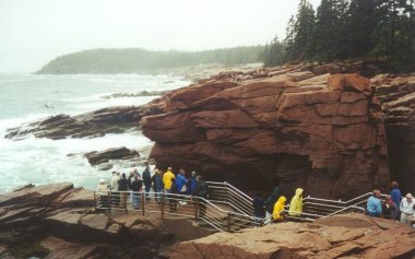 We took the 27-mile Park Loop Road located on Schoodic Peninsula after acquiring a guided cassette tape of the tour at the Hull's Cove Visitors Center on Route 3. The center is located about one hour north of Bar Harbor. We took the 27-mile Park Loop Road located on Schoodic Peninsula after acquiring a guided cassette tape of the tour at the Hull's Cove Visitors Center on Route 3. The center is located about one hour north of Bar Harbor.The driving tour (that took us two half days, and we were still not finished) covers the entire Park Loop Road, as well as Sargent Drive along lovely Somes Sound. Scenic points of interest are highlighted, and the park's natural and cultural history is explained. Some of the sights we saw were Sand Beach, Gotham Mountain, Seal harbor, Otter Cliffs, and Cadillac Mountain. While on the auto tour we explored Thunder Hole, a familiar example of the awesome power of the sea. When the wind is strong, the rising tide surges into the narrow chasm, compressing the captured air, and resounds with a boom that is felt as well as heard. The surging tides throw stones, some as large as bowling balls, on the chasm floor. These stones are hurled against the bottleneck of rock in a ceaseless effort to tunnel deeper. It was alot more scenic when fog doesn't mask the beauty of the area, although I did get a few good photos with fog in the background. 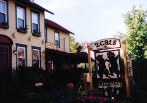 The 2 Cats restaurant is a Bar Harbor inn, restaurant, and bed and breakfast at 130 Cottage Street that features cat themed gifts, collectibles, and Downeast Maine lodging hospitality. The 2 Cats restaurant is a Bar Harbor inn, restaurant, and bed and breakfast at 130 Cottage Street that features cat themed gifts, collectibles, and Downeast Maine lodging hospitality.In the town of Bar Harbor, at low tide one can wander out across the gravel bar that leads to Bar Island. After 90 minutes, your footpath will disappear beneath the inomcing tide. Thanks, Laurie, for the web site information! And thanks to Dan for the photograph! (We seem to have a common link with all of our trips -- dogs and cats.) 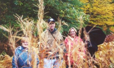 The sign in front of The Wild Gardens of Acadia states that "A Thing Of Beauty Is A Joy Forever" and describes its history as "The Bar Harbor Garden Club in cooperation with Acadia National park established for all to enjoy - the Wild Gardens of Acadia in 1961. The Gardens, displaying native trees, shrubs, wildflowers, and ferns, reflect in microcosm the diversity and beauty of the park at large. This marker, erected in 1986, commemorates the countless hours and loving care the Club volunteers have devoted to the gardens, a living field guide to the plants of acadia." Among the more prominant trees in the park is the red spruce (reddish-brown bark and sharp, stiff needles), white spruce (silvery-brown bark and bluish-green needles), red, pitch, jack, and white pines (once much valued for sailing ship masts), and paper birch (tough, white bark once used to craft baskets, canoes, and wigwams). The sign in front of The Wild Gardens of Acadia states that "A Thing Of Beauty Is A Joy Forever" and describes its history as "The Bar Harbor Garden Club in cooperation with Acadia National park established for all to enjoy - the Wild Gardens of Acadia in 1961. The Gardens, displaying native trees, shrubs, wildflowers, and ferns, reflect in microcosm the diversity and beauty of the park at large. This marker, erected in 1986, commemorates the countless hours and loving care the Club volunteers have devoted to the gardens, a living field guide to the plants of acadia." Among the more prominant trees in the park is the red spruce (reddish-brown bark and sharp, stiff needles), white spruce (silvery-brown bark and bluish-green needles), red, pitch, jack, and white pines (once much valued for sailing ship masts), and paper birch (tough, white bark once used to craft baskets, canoes, and wigwams).
 Janice, Ward, Mary, and Nicole pose for a photograph within The Wild Gardens of Acadia, a project of the Bar Harbor Garden Club. These gardens present a miniature view of the variety of plants that grow on the mountains, in the marshes, and along the beaches of Mt. Desert Island. The plants are grouped according to their ecological needs. The Wild Garden is located at the Sieur de Monts Spring entrance. Their telephone number is 288-3400. Janice, Ward, Mary, and Nicole pose for a photograph within The Wild Gardens of Acadia, a project of the Bar Harbor Garden Club. These gardens present a miniature view of the variety of plants that grow on the mountains, in the marshes, and along the beaches of Mt. Desert Island. The plants are grouped according to their ecological needs. The Wild Garden is located at the Sieur de Monts Spring entrance. Their telephone number is 288-3400.Mike, Harriet, Maureen, and Bill are also exploring the gardens during this time.  And.....Nancy, Tom, Laurie, and Dan are also exploring at this time, too. And.....Nancy, Tom, Laurie, and Dan are also exploring at this time, too.Thanks Nick for the photograph! 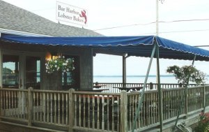 Nick also has done some preliminary searchs on a lobster bake: Here's some info on it:"I contacted lobsterbakes and they server muscles, corn, potatoes and one lobster for $25.00. Due to the number of people in town that weekend, reservations would be a wise thing. I have reserved a table of 14 for Oct 7th at 5:30pm which is the only room available at this particular restaurant. Hopefully this is ok with everyone. If there are some people that don't like lobster or are allergic, they offer steak or baked halibut as a substitute. I just need to let Anne know before hand. They would also instruct you on how to eat lobster if needed. Again, this is written in stone but it sounds like if would be a lot of fun." UPDATE: For the Lobster Bake it looks like we'll need a reservation for 17. 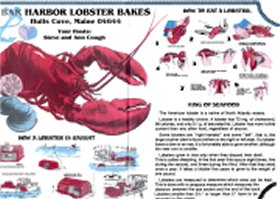
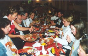 Everyone is busy eating. Ward, Nicole, & Mike and Nancy & Tom P (below left photo) are lobster-ready, with the lobster bibs in the eating position. While (below right photo) Dan and Melinda appear to be finished eating. Nick has provided the below two photographs. Thanks Nick! 
 We are at Bar Harbor Lobster Bakes, Hulls Cove, Maine 04644. Our hosts are Steve and Ann Cough where most of us had lobster and a couple of us had the halibut. The American lobster is a native of North Atlantic waters. Did you know that some lobsters are "right handed" and some "left". That is, the large crusher claw is found either on the right or left side. If a lobster loses a claw or an eye, it is able to grow another, although the new one is smaller. Lobsters grow in size only when they discard their shell, called shedding. It takes a lobster about five years to grow to the weight of one pound. Lobsters live on the ocean floor, where they feed on snails, clams, mussels, and other marine life. Lobstermen catch their prey using box-shaped wire traps that they drop overboard and mark with brightly painted buoys (whose distinctive color combinations are registered with the state). 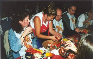 Tom is given instructions on how to eat a lobster, as Maureen looks on. To eat a cooked lobster, you need a nutcracker, a lobster bib, and lots of melted butter. Twist off the front claws, crack them open, and remove the meat. Break off the tail from the body and use a fork to push the meat out. Though small, the lobster's eight remaining legs contain good meat, and the best way to get at it is to suck it out. Tom is given instructions on how to eat a lobster, as Maureen looks on. To eat a cooked lobster, you need a nutcracker, a lobster bib, and lots of melted butter. Twist off the front claws, crack them open, and remove the meat. Break off the tail from the body and use a fork to push the meat out. Though small, the lobster's eight remaining legs contain good meat, and the best way to get at it is to suck it out.
 Melinda, whose parents live closeby, and Laurie's sister Linda also joined us for dinner. Here, Laurie has finished her lobster and now is ready for ! THREE ! portions of dessert! Afterwards some of us went to downtown Bar Harbor to shop and look around. While others went to The Manor Inn in Castine. Information William Arthur Atkins e-mail: williamatkins3307 [at] comcast.net home URL: http://www.WilliamArthurAtkins.com
|